Traveler's Guide
East Macedonia & Thrace


Region of East Macedonia & Thrace
The Region of Eastern Macedonia and Thrace occupies the northeastern part of Greece. It borders with Turkey easterly, Bulgaria northern and with the Regional Unit of Serres westerly. Southwest is washed by the Aegean Sea and southeast by the Thracian Sea. It includes the Regional Unities: Drama, Kavala, Xanthi, Rodopi and Evros.
It has a total area of 14.157 thousand hectares and covers the 10.7% of the total area of the country.
Also includes two major islands of Thracian Sea, Thassos and Samothrace.
Crossroad of major sea and land routes by which, for thousands of years, are moving people and goods, ideas and habits to and from the four cardinal points: from the Black Sea and Asia to Western Europe and from North Europe and the Balkans to the Mediterranean and North Africa.
The traces of its history, that start from the Paleolithic season and arrive to our days, are everywhere: caves, rock paintings, forts, temples, theaters, citadels, mines, graves, tumuli, marble quarries, Christian monuments, monasteries and holy places , aqueducts, Islamic monuments, traditional villages, Megara, mansions, tobacco warehouses.
The Region of Eastern Macedonia and Thrace, during the ancient times, was covered by forests at the rate of about 80%, but today this percentage has limited to 55% per area. In its extent there are trackless forests, virgin nature, high mountains, rich flora and fauna, large rivers, lakes and lagoons and an endless coastline with clear blue waters and friendly beaches.
The region is a place of music, dance, feast and ritual. Dionysus and Orpheus never left from this earth. The reversals of nature (winter, spring, etc.) give an opportunity for reversals of another class: masquerading and walking over fires, and outspoken sprees, kidnappings and robberies, all in the context of ritual.
Polystylo of Abdera
 The Byzantine township of Polystylon occupies the acropolis of the ancient city of Abdera. Its defences, approximately 800 metres long, follow more or less the contours of the hill. Built ...
The Fortress
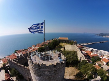 The Acropolis of Kavala, built around the first quarter of 15th century,
stands at the top of Panagia peninsula where the old town is situated.
It was built on the ...
The Acropolis of Kavala, built around the first quarter of 15th century,
stands at the top of Panagia peninsula where the old town is situated.
It was built on the ...
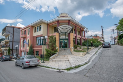
Building at the Joachim III Street
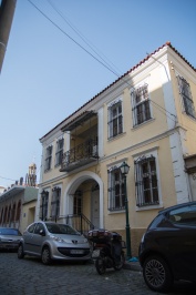 The building at the Joachim III Street, property of Ant. Georgios, together with the surroundings of its plot, are declared historical monument and artwork that needs special government protection, as ...
Halil Bey Mosque (Old Music)
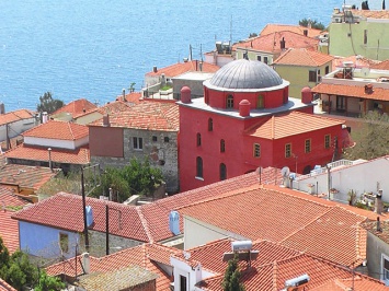 The complex Halil Bey includes the homonymous mosque of the 16th century, built on the foundations of an early Christian basilica, and the madrassa (sacred teaching). The 8 rooms of ...
Tekes of Kizil Deli
 The Tekes of Segit Ali Sultan, known also as Tekes of Kizil Deli or Tekes of Roussa is located 3 km outside the village Roussa (Turkish: Ruşenler, Rousenler), inhabited mostly ...
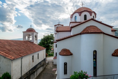
HOLY TEMPLE OF PANAGIA
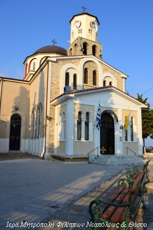 The Orthodox Church of the Assumption is
located in the historic district of Panagia, within the walls of the
peninsula, where half of the residents and families that lived during ...
The Orthodox Church of the Assumption is
located in the historic district of Panagia, within the walls of the
peninsula, where half of the residents and families that lived during ...
Sanative Spring in Eleftheres
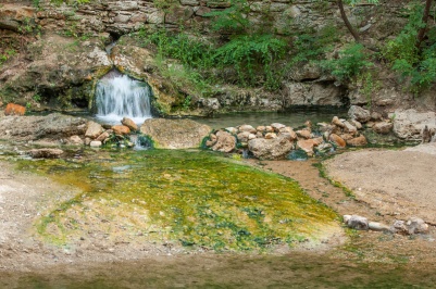 The Baths of Sanative Springs of Eleftheres are an area of unique natural beauty, located 45 km west of Kavala city in the coastal highway to Thessaloniki, in a strategic ...
Makriammos Beach
 Leaving the city of Kavala you meet the Aspri Ammos (White Sand) Beach, a quaint bay with a lovely sandy beach organized with tavernas and a few kilometers further down, ...
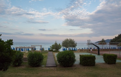
Beach of Pefkari
 The Peukari got its name from the pine forest in the area. The beach is known for its deep clear waters and water sports center (water sports).
Alexandroupoli
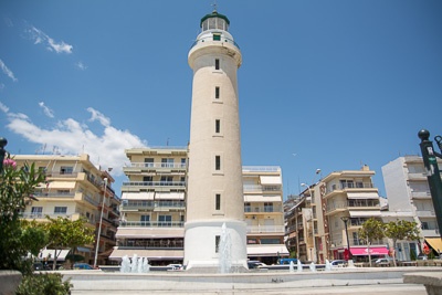 The capital of the prefecture is a modern tourist town with many hotels, countless restaurants, cafés and a major trading center. The city was just 30 km away from the ...
K. Nevrokopi
 Kato Neurokopi is a town of the Prefecture of Drama in altitude of 558 m, it is situated in the center of the homonymous plateau, northwest of Drama 47km away ...
Monastiraki
 Located on the eastern slopes of Falakro, north of the city of Drama and within 5 km from the city center. A village with a tradition of exploitation the marble.In ...


- [Home][CULTURE][RELIGION]
- [NATURE]
- BEACHES
- FORESTS
- WILDLIFE SHELTERS
- CANYONS
- RIVERS
- CAVES
- NATURA
- LAKES
- WATERFALLS
- HOT SPRINGS
- MOUNTAINS
- PARKS
- AGROTOURISM
- ALTERNATIVE
- MUSEUMS
- SIGHTS
- [CONFERENCE ][ACTIVITIES][INFORMATION]
- [ΑCCOMMODATION][FOOD AND DRINK][ΤOURIST SERVICES]
- [POINTS OF INFORMATION][HEALTH][COMMERCE]
- [ENTERTAINMENT]
Privacy Policy
Intellectual and Industrial Property Rights - Responsibility of the Site and the Region of East Macedonia & Thrace
The content of this portal has been collected and evaluated by each partner of the project (Region of East Macedonia & Thrace, Regional Administration of Smolyan, Regional administration of Kardzhali και Regional Administration of Haskovo) for the area which each partner represents. Each partner represents each region for the implementation of the Action 3.2 "Content Collection" for the approved applitcation form of JTI - TARGET project under "Greece - Bulgaria 2007 -2013" Interreg Call. The content including images, photos, graphics, texts, textures and in general all the data of the portal is in the responsibility of each partner. The content update and upload of each region belongs to each partner which has also the copyright for those content. This means that the content in this portal of all the point of interests of the Region of Smolyan belongs to the Partner Regional Administration of Smolyan. The content in this portal of all the point of interests of the Region of Haskovo belongs to the Partner Regional Administration of Haskovo, The content in this portal of all the point of interests of the Region of Kardzhali belongs to the Partner Regional Administration of Kardzhali, The content in this portal of all the point of interests of the Region of Region of East Macedonia & Thrace belongs to the Partner Region of East Macedonia & Thrace.
Given the nature and the size of the Internet, under no circumstances, including the case of negligence, will the Region of East Macedonia & Thrace is not responsible for any kind of loss caused to the visitor/user of the pages, services, choices and contents of this portal, which one undertakes at one’s own initiative. The portal and the Region of East Macedonia & Thrace do not guarantee that the pages, the services, the choices and the contents will be provided non-stop and without errors and that the errors will be corrected, because each content belongs to the Region that belongs. Furthermore, the portal and the Region of East Macedonia & Thrace do not guarantee that the servers, through which it is made available to users, do not contain “viruses” or other harmful contents. The Region of East Macedonia & Thrace guarantee the correctness, completeness or even the availability of the contents, pages, services, choices or their results only for its Region, not for the other Regions.
Links to other Websites
The Portal and the Region of East Macedonia & Thrace do not control the availability, the content, the personal data protection policy, the quality and the completeness of the services of other web sites and pages to which it directs users through hyperlinks. Consequently, for any problem arising during their visit/use, the user has to address directly the corresponding web sites and pages, which have the full responsibility for the delivery of their services. The Portal and the Region of East Macedonia & Thrace can under no circumstances be considered to agree with or accept the content or the services of the web sites and the pages to which it directs users or to be associated with them in any way.
Applicable Law and other Conditions
The aforementioned terms and conditions of the use of the Portal, as well as any modification of them, are governed and completed by the Greek law, the law of the European Union and the relevant international treaties (like indicatively and not restrictively the Law 2472/1997 for the protection of the individual and the protection of personal data, as completed by the decisions of the Chairman of the Committee for the Protection of Personal Data, the Presidential Decrees 207/1998 and 79/2000 and Article 8 of the Law 2819/2000, as well as the Law 2774/1999 and the European Law (directives 95/46/EC and 97/66/EC). Any provision of the above conditions that becomes opposing to the law, it ceases to apply by right and is removed from the present, without the validity of the remaining conditions being affected in any case. No modification of these conditions will be taken into account and will be part of this agreement, unless it has been officially formulated and incorporated into it.
