Reisesführer
Smolyan Region


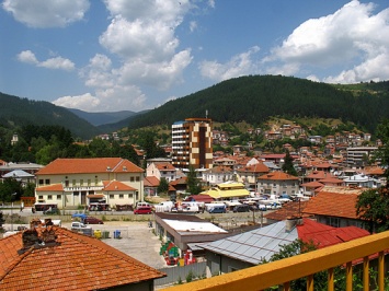
PRESENTATION OF SMOLYAN REGION
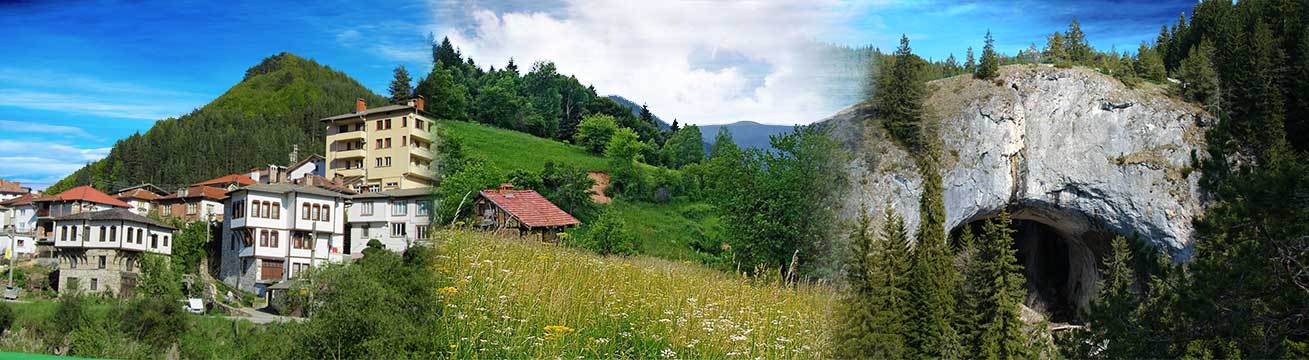
Smolyan region is situated in South Bulgaria, in the central part of the Rhodopes, on a territory of 3194 sq.km, that takes 2,9% of the whole territory of the country. It΄s bounded with the regions of Plovdiv, Pazardjik, Kardjally, Blagoevgrad and to the south – with Greece republic. Woodland stretches on a big part of the territory – 2531 thousand decares (70%) and agricultural lands cover 825 thousands decares (25%).
The climate in Smolyan Region is defined by the combined action of typical European moderate continental climate, the high above sea level, the mild and warm Mediterranean winds, coming from the relatively close situated Aegean Sea and solar radiation. The middle temperature of the air during the year is 5 – 10 º C.
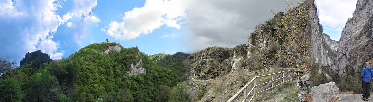
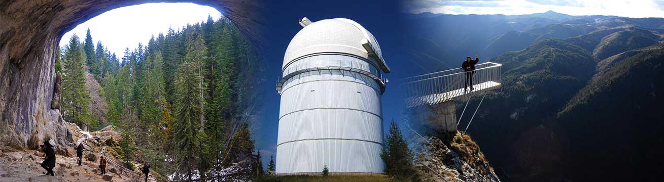
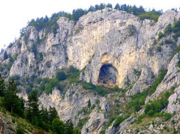
The altitude of the region varies from 600 m up to 2191 m. above the sea level. Smolyan Region includes The Rhodopes highest part, including Perelik share, with the highest peak Golyam Perelik (2 191 meters above sea level mas). The number of peaks above 2000 mas is four: Golyam Perelik (2191 mas), Golyam Snezhnik (Karlak)(2188 mas), Golyam Persenk (2091 mas) and Persenk (2074 mas). The relief in separate municipalities (Madan, Nedelino, Rudozem, Devin) is mountainous-hilly. The average above sea level in these is lower – 600 – 700 meters. Typically mountainous are the municipalities of Smolyan, Chepelare, Borino, Dospat. The average above sea level there is round and above 1200 meters. At a comparatively small area in the region nature has formed a great variety of rocks (marbles, rhyolites, sandstones). The upheaval of these in the geological periods has saturated the region with attractive rocky formations, like canyons, gorges, caves, peaks with wonderful panoramic views.The presence of a number of caves is characteristic (about 900 in number); just three of these, however, belonging to the Smolyan region have been well laid out. These three have a great significance for tourism development: Yagodinska (Yagodina village, Borino municipality), Dyavolsko garlo (Trigrad village, Devin municipality), Uhlovitsa (Mogilitsa village, Smolyan municipality). The prevailing part of caves are a real challenge to thrill seekers. The access to them is only with guides – speleologists; specialized equipment is supplied by cave and mountainous clubs. Caves themselves, as well as their surrounding areas, are suitable for practicing different types of extreme sports like rock-climbing, not well laid out caves penetration, mountain biking, etc.
The Region is famous with a series of other natural formations: Chudnite mostove, Slona, Trigradsko and Buynovsko gorges. Waterfalls’ canyon, Orfeevi skali (rocks), groups of rocks Kichikaya, Sadilishteto, the rocky crown above Smolyan.
The bigger rivers in the region are Arda (241.3 km), Vacha (111.5 km) and Chepelarska (85.9 km). Their upper river valleys are very picturesque with the cut in the rocks gorges and canyons. They are also attractive for fishing tourism.
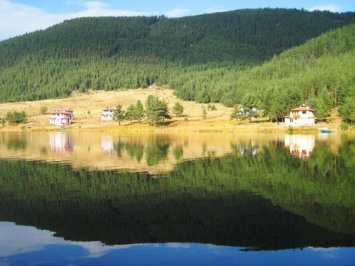
There are 2 big dams in Devin municipality –Vacha and Tcankov kamak; the second biggest dam in this country is in Dospat municipality – Dospat dam (420 mln cubic m). It is used for electricity production, fish breeding, fishing and water tourism. Other prominent water reservoirs are Zlatograd dam and a series of micro-dams. In the Smolyan valley northern part Smolyan lakes are located, which are often called „Orpheus’ mountain eyes”.
Smolyan Region is one of the richest in mineral waters in this country. Mineral waters in Devin municipality have very good properties 16º to 76ºС in the deposits „Bedenski bani” near Breze village, in the town of Devin (water with very good table qualities), Mihalkovo village (the most aerated in a natural way vaglekisela water in this country table and healing with a temperature of 16-26 ºС), „Posestra”area and in Nastan quarter „Nastan 1” and „Nastan 2”. Mineral water has an inner as well as outer application for healing a series of diseases.
The thermal spring in Banite village has a discharge of 18 l/sec and a temperature of 35-43оС and mineralization about 900 mg/l, which defines the development of balneo-healing and SPA tourism in the municipality.
The Middle Rhodopes have preserved a considerable biodiversity - out of the flora representatives 60 species are world important, 40 species are Bulgarian endemic and 45 species are Balkan endemic. The region is one of the few in Europe, inhabited by brown bear, wild goat and wolf in natural conditions.
Protected areas are places, requiring special care on behalf of the state. The access to them has been regulated by the Protected Areas Law and it is based on the regime of visits according to the protected area category (Protected Areas Law, 1997). There are 48 protected areas in the region the more prominent.
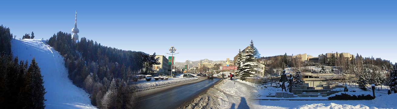
The preserved natural environment is one of the specific advantages in the region, as well as the availability of natural resources – ore, mineral water, forest areas, and the second largest winter and ski resort in the country – Pamporovo. Production experience and traditions in the fields of tourism, potato-production, ore mining, cable and semi-conductors production, ski-production, timber industry, sewing and knitwear industry are presented. Protected natural sites, spacious woodlands, clear rivers and water basins, mineral springs are situated on the territory of the region, characterized by wide variety in relief and landscapes.
Thear are 9 forests, the most prominent of which are Momchilova krepost (Fortress) near Gradat village, Kaleto by Smolyan, Zagrad in Chepelare municipality, Kaleto in Struilitsa district, Devin (municipality) the forest at Koshnitsa village, the Koznik forest in Rudozem municipality, etc.; and over 10 Thracian sanctuaries.
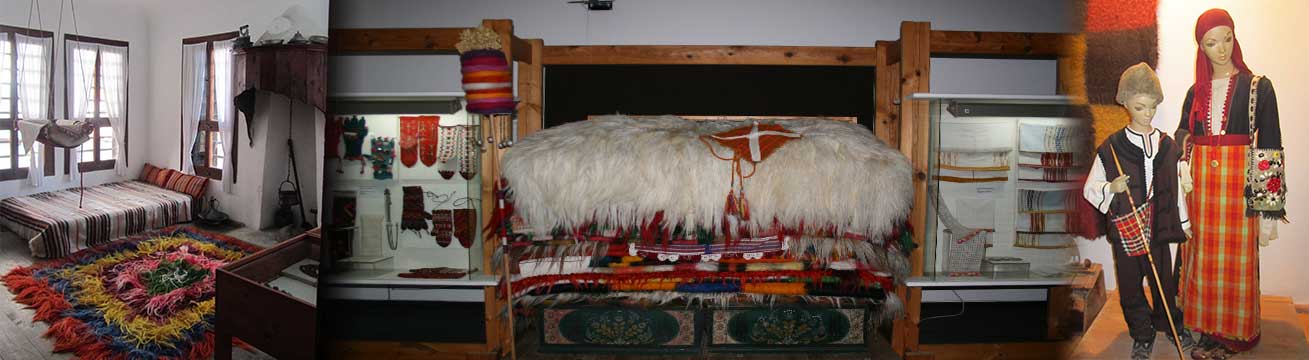
In Smolyan Region are 17 museums and galleries. The greatest number of them is located in Smolyan municipality – 9 of them.
We shall make a presentation of two of the most remarkable anthropogenic sites in the region – the National Astronomical Observatory (NAO) at Rozhen peak and the Planetarium in Smolyan. These are sites, which are a resource for both cognitive and scientific and educational tourism.The NAO is the biggest in Southeastern Europe observation complex in the field of optical astrophysics. The observatory disposes of 4 telescopes and is open for visits by tourists. The Smolyan Planetarium is the biggest site of the type in Bulgaria.
Could be drawn that the Smolyan Region anthropogenic resources are not less attractive than the natural environment resources. This part of Bulgaria has been for a long time promoted as a destination for different types of tourism, based on natural heritage.
Smolyan Region has a comparatively undeveloped economic basis – with 2.9% of the territory of the country and 1.6% of the population of the country, hardly 1.15% of the gross value added (GVA) and of the GDP in Bulgaria are produced. The GDP per capita is with 2 772 BGN less than the average GDP in this country and represents 30.8% smaller value than the average. The greatest tribute to the gross production has Smolyan municipality, to be followed by Rudozem and Zlatograd municipalities.
There are 10 municipalities on the territory of Smolyan region (Banite, Borino, Devin, Dospat, Zlatograd, Madan, Nedelino, Roudozem, Smolyan, Chepelare), comprising 242 settlements, 8 of them – towns. The population of the region is 120 456 inhabitants. The biggest municipality is Smolyan with 40941 inhabitants, and the smallest one is Borino – 3597 inhabitants. The region of Smolyan has a wide range of natural and anthropogenic recreation resources and is therefore the most prominent tourist area in the West Rhodope Region. There are several industrial centers – Smolyan, Roudozem, Chepelare, Zlatograd, Dospat and Devin.
The constant population in Smolyan Region at the end of 2011 was 120 456 people at an average density of 37.7 persons per square meter (psm). The average density for this country was 66 persons psm.
Kastrakliy
 The nature reserve “Kastrakli” occupies 124 hectares in the territory of Borino. The reserve is known for its favorable climate which created good conditions for human settlement, first by the ...
Kazanite
 The Kazanite Reserve is located in the area of the village of Gyovren in the west Rhodope Mountain. It was declared a reserve by Order No 508 of 28 March ...
Shiroka Luka
 Shiroka Laka Village befindet sich in den Rhodopen, 23 km nordöstlich von Smoljan und 16 km von Pamporovo entfernt. Der Name des Dorfes stammt aus der alten bulgarischen Wort "Laka" ...
Haramiiska cave
 The Haramiyska Cave is located in the Trigrad Gorge in the Rhodope Mountains, close to the famous Devil’s Throat Cave. It is a destination for those interested in extreme tourism, ...
“St. Prophet Ilija” Church, Davidkovo village
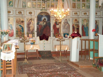 It was built in its present appearance in 1923 and is one of the oldest and most beautiful cultural monuments on the territory of the municipality. The iconostasis is a ...
Bulgarischen Dudelsack-Wettbewerb und "Ilinden" Versammlung - Gela Dorf
 Seit vielen Jahren am Anfang August einheimischen Familien haben auf den Wiesen bei Ilinden Gela Dorf in den Rhodopen versammelt zu chatten und sich freuen. Die Tradition hat sich bis ...
Dospat Dam
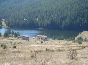 The dam of Dospat is situated in the heart of the fairy Rhodope mountains, in immediate proximity of the town of the same name, at distance of 82 km. west ...
Kristallhalle "Rodopski Kristal", die Stadt der Madan
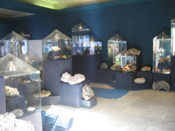 Die Rhodopen Kristallhalle ist eines der besten Sehenswürdigkeiten der Stadt Madan. Es wurde im Jahr 1984 gegründet wurde, speichert 581 Mineralien, und ist Mitglied der Internationalen Vereinigung der Mineralogischen Museums.Die ...
International Hip-hop and Funk festival "Jam On It"
 International Forum for hip-hop and unerground culture held in autumn.
Horse base "Petro-G" Ltd. - Levochevo village
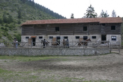 Horse base "Petro-G" Ltd. - Levochevo village provides horse riding trips to various local destinations.
Chepelare
 Chepelare occupies a small valley at the heart of the Rodoppi Mountain. The beautiful Chepelare River passes through the pretty town. Chepelare is 222 kilometers away from Sofia and just ...
Museum of Ski and Ski Sport
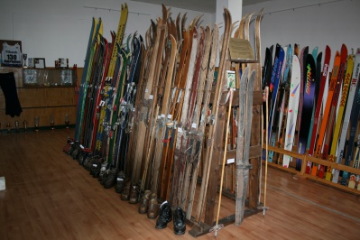 The Museum of the skis and ski-sports in Chepelare is unique for Bulgaria. It is housed in the building of the community center "Rhodopska Iskra" in the town. The museum ...
Privacy Policy
Intellectual and Industrial Property Rights - Responsibility of the Site and the Region of East Macedonia & Thrace
Except for the expressly stated exemptions (intellectual rights of third
parties, partners and bodies), the entire content of this portal, including
images, graphics, photographs, plans, texts, services provided and all the
files of this website in general, are the intellectual property and the logos
of the offices of the Region of East Macedonia & Thrace and are protected
by the relevant provisions of the Greek law, the European law and international
agreements and treaties. Consequently, none of them can be, in part or as a
whole, sold, copied, modified, reproduced, republished, “loaded”, transmitted
or distributed in any way. Any products or services mentioned in the web pages
of this portal bearing the logos of the corresponding organizations, companies,
co-operating bodies, unions or publications, are their own intellectual and
industrial property and therefore these bodies have the relevant
responsibility. The Region of East Macedonia & Thrace does not have any responsibility
for the content that describes any point of interest. The user understands and
accepts that he/she is not given the right to reproduce, copy, sell, re-sell
and/or commercially exploit in any way part or the whole of the content of the
Portal without a special written permission of the Region of East Macedonia
& Thrace, provided upon request of the interested person.
Given the nature and the size of the Internet, under no circumstances,
including the case of negligence, will the Region of East Macedonia &
Thrace be responsible for any kind of loss caused to the visitor/user of the
pages, services, choices and contents of this portal, which one undertakes at
one’s own initiative. The portal and the Region of East Macedonia & Thrace
do not guarantee that the pages, the services, the choices and the contents
will be provided non-stop and without errors and that the errors will be
corrected. Furthermore, the portal and the Region of East Macedonia &
Thrace do not guarantee that the servers, through which it is made available to
users, do not contain “viruses” or other harmful contents. The Portal and the
Region of East Macedonia & Thrace guarantee in no case the correctness,
completeness or even the availability of the contents, pages, services, choices
or their results. The cost of eventual corrections or servicing is undertaken
by the visitor/user and in no case by the Portal and the Region of East
Macedonia & Thrace.
Links to other Websites
The Portal and the Region of East Macedonia & Thrace do not control the availability, the content, the personal data protection policy, the quality and the completeness of the services of other web sites and pages to which it directs users through hyperlinks. Consequently, for any problem arising during their visit/use, the user has to address directly the corresponding web sites and pages, which have the full responsibility for the delivery of their services. The Portal and the Region of East Macedonia & Thrace can under no circumstances be considered to agree with or accept the content or the services of the web sites and the pages to which it directs users or to be associated with them in any way.
Applicable Law and other Conditions
The aforementioned terms and conditions of the use of the Portal, as well as any modification of them, are governed and completed by the Greek law, the law of the European Union and the relevant international treaties (like indicatively and not restrictively the Law 2472/1997 for the protection of the individual and the protection of personal data, as completed by the decisions of the Chairman of the Committee for the Protection of Personal Data, the Presidential Decrees 207/1998 and 79/2000 and Article 8 of the Law 2819/2000, as well as the Law 2774/1999 and the European Law (directives 95/46/EC and 97/66/EC). Any provision of the above conditions that becomes opposing to the law, it ceases to apply by right and is removed from the present, without the validity of the remaining conditions being affected in any case. No modification of these conditions will be taken into account and will be part of this agreement, unless it has been officially formulated and incorporated into it.
